|
|
|||||||||||
Where is this? Scottys Fishing/Backpack Adventure |
||||||||||||
| Another great video from Scotty, but where is it?
Check here for my guesses |
||||||||||||
Access and Fishing Notes |
||||||||||||
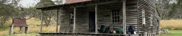
| I think the route taken is roughly as shown on the map. Note that this route is very approximate as, for a lot of the route, there is no recognised track to follow.
The following points seem to be shown on the video. The parking spot is on the side of the B72 at the junction with the Gooandra Trail, around -35.81388, 148.49645. Time 6:38 is around the junction of Nungar Creek Trail and Alpine Creek Trail (-35.82998, 148.56697). Time 7:34 is probably looking up Tantangara Creek at -35.83881, 148.56991. Time 7:42 is a fantastic view looking North, downstream along Boggy Plain Creek from about -35.84145, 148.57367. Time 8:27 is somewhere around -35.84455, 148.57962 in amongst the boulders around Boggy Plain Creek. Not sure exactly where the camp site is, but it's in that region. Time 18:46 where the boulders are blocking the creek seems to be at -35.83994, 148.58193. Time from 28:21, the hut is Gooandra Homestead at -35.80052, 148.53664. |
||||||||||||
Feel free to leave a comment or question. Include your email address if you want a private answer (email will not be shown). It takes a little while for the comment to appear as our AI bot checks for offensive or inappropriate comments! We reserve the right to edit comments to remove unsuitable content. |
||||||||||||
|
||||||||||||
|
| ||||||||||||