|
|
|||||||||||
Where is this? Chris Bammans High-country Trout Fishing Adventure |
||||||||||||
| Here's another Australian High Country fishing video; this one from Chris Bamman.
If you want to know where it is check here! |
||||||||||||
Access and Fishing Notes |
||||||||||||
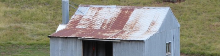
| The hut in the video is Hains Hut on the Murrumbidgee River. It was built as a fishing hut in the 1940's. Lat/Long is -35.76980, 148.59179.
Time 0:20 Access is via the Bullocks Hill Trail, which leaves the B72 at -35.77551, 148.51420, so that's probably the track shown. Time 0:45 Probably parking at Tantangara Creek camping ground, then crossing the creek and walking along the trail to the Hains Hut Trail turn off that goes to the Hut. The approximate track is marked in red but the actual track is also shown on the map if you zoom in. Time 4:05 Fishing is along the Murrumbidgee River, near the hut. Reverse the walk to get back to the car and drive out. |
||||||||||||
Feel free to leave a comment or question. Include your email address if you want a private answer (email will not be shown). It takes a little while for the comment to appear as our AI bot checks for offensive or inappropriate comments! We reserve the right to edit comments to remove unsuitable content. |
||||||||||||
|
||||||||||||
|
| ||||||||||||