|
View on map: Sydney |
Central Japan
|
|
|
Bantry Bay - Review route carefully! |
8-11km
2.5-3.5hrs
91m
|
|
 |
| This is a hike around Bantry Bay to Roseville Bridge. Read carefully before following my route. |
|
...more [1167] |
|
|
|
|
Devlins Creek and Kurrajong Track |
8.0km
2hr
150m
|
|
 |
| This walk takes you through part of the Lane Cove National Park, starting at South Turramurra, heading towards Cheltenham and then returning on Pennant Hills Fire Trail. |
|
...more [1103] |
|
|
|
|
|
|
|
|
Lane Cove River Trail Circuit |
11.5km
3hrs
|
|
 |
| This walk takes you on a circuit along both sides of the Lane Cove River. I think this walk had the highest number of wildlife sightings I've had on any walk in Sydney. |
|
...more [1136] |
|
|
|
|
West Head, Resolute Track and Great Mackerel Beach |
6.3km
2hr
178m
|
|
 |
| The walk takes you from West Head, anti-clockwise around the Resolute Track, taking in a couple of short side trips to Great Mackerel Beach and West Head Beach. |
|
...more [1023] |
|
|
|
|
Narrabeen Lagoon Circuit |
8.8km
1hr 35min
A few metres
|
|
 |
| This is an easy, flat walk around the main section of Narrabeen Lagoon (upstream of the bridge). All parts of the track are easy walking along a wide dirt or prepared surface track.
The track is often busy with walkers and cyclists and runs next to a main road in places, so is not for those looking for quiet walking. |
|
...more [968] |
|
|
|
|
Manly Dam Circuit |
8.7km
2hrs 40min
101m
|
|
 |
| Manly Dam Circuit is a mixed walk with some lakeside and bush walking. Some parts of the track are easy flat walking but there are some moderate climbs and steps.
There are options to reduce the number of steps by using the lakeside drive in places. |
|
...more [654] |
|
|
|
|
|
|
|
|
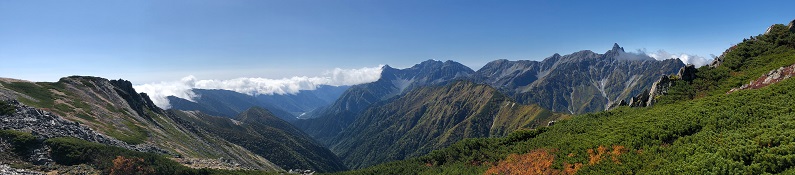
Panorama-Ginza Full Route Plan |
32.9km
4 days
2922m
|
|
 |
| This item outlines our plan for the Panorama-Ginza hike in the Southern part of the Japanese Kita Alps with a final destination of Kamikochi.
Technical Level according the Nagano Trail Grades guide is B (Streams, cliffs and snowy valleys in some trails. Steep ups and downs. Some sections not clearly indicated. Some possibility of falling and sliding down if you trip.)
Physical Level is 8 (2-3 nights or longer) |
|
...more [1734] |
|
|
|
|
Panorama Ginza Day 5 - Kamikochi |
4km
1.5hrs
1556m
|
|
 |
| Day 5 of Panorama Ginza, There's time for a leisurely breakfast as it's only a short walk to Kamikochi. The path to the North of the river is slightly longer but more interesting than the path to the South.
The walk ends at Kamikochi bus station. |
|
...more [725] |
|
|
|
|
Panorama Ginza Day 4 - Chogatake and Myojinkan hut |
9.2km
5hrs
2677m
|
|
 |
| Day 4 of Panorama Ginza, It's a very short climb to the summit of Chogatake (2677m) then begin a long descent into the valley, arriving at Tokusawa hut.
From there, it's an easy walk down the valley to Myojinkan hut. |
|
...more [772] |
|
|
|
|
Panorama Ginza Day 3 - Jonendake and Chogatake hut |
6.9km
7.5hrs
2857m
|
|
 |
| Day 3 of Panorama Ginza, Set off early to make the steep climb from the hut to the summit of Jonendake (2857m).
Beyond Jonendake summit there's a steep descent, followed by a long undulating ridge leading towards Chogatake hut, the stop for the night. |
|
...more [914] |
|
|
|
|
|
|
|
|
Panorama Ginza Day 2 - Otensho and Jonen hut |
11.2km
8hrs
2922m
|
|
 |
| Day 2 of Panorama Ginza, Follow the ridge to Otensho hut and then make the short climb to the summit of Mount Otensho, the highest point on this walk at 2922m.
After Otensho hut, take the ridge to the East and follow that before eventually descending to Jonen hut, the stop for the night. |
|
...more [856] |
|
|
|
|
Panorama Ginza Day 1 - Tsubakurodake and Enzanso hut |
7.0km
6hrs
2763m
|
|
 |
| Day 1 of Panorama Ginza, Climb battle ridge past Kassen-Goya hut, up to Enzanso hut and then on to the summit of Tsubakurodake at 2762.9m.
Return to spend the night at Enzanso hut. |
|
...more [819] |
|
|
|
|
Ureyama through Aichi Prefectural Forest |
12.0km
8hrs
934m
|
|
 |
| This route is mainly in the Aichi Prefectural Forest Park. It goes up a ridge to the summit and then drops down to the valley and along the river to return.
The goal is Mt Ureyama (929.7m). There are several alternative routes and circuits within the park.
|
|
...more [947] |
|
|
|
|
Hokkaido: Kurodake and Ohachidaira Caldera |
9.0km
4hrs
1996m
|
|
 |
| This is a return hike up to the summit of Mt. Kurodake, then past Kurodake hut and on to Ohachidaira Caldera lookout. Return on the reverse route.
Take the Ropeway from Sounkyo and then the Chair Lift to get to the Trail Head. |
|
...more [654] |
|
|
|
|